Clouds and cool temps for Thursday with more wet weather on tap for Friday
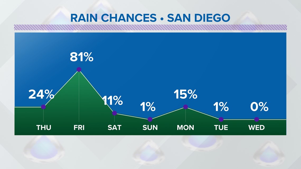
Clouds and isolated light showers are possible on Thursday. Another cold storm system will bring back scattered rain, mountain snow and colder temps on Friday. Another cold storm system is set to bring scattered rain, mountain snow, and colder temperatures on Friday. This will be followed by a significant inland drop in temperatures from Wednesday through Friday, with a good chance of scattered rain and high surf and seas. The strongest winds will be felt on Thursday afternoon, with wind gusts reaching the west of the mountains. The potential for scattered showers will impact most of San Diego county on Friday, leading to a potential for a significant drop in inland temperatures by 10 to 30 degrees. A Wind Advisory has been issued for those parts of the mountain and desert. The storm system will also cause water issues for San Diego as well.
Pubblicato : un mese fa di News 8 Weather Team in Weather
Clouds and isolated light showers are possible on Thursday. Another cold storm system will bring back scattered rain, mountain snow and colder temps on Friday.
Example video title will go here for this video
Example video title will go here for this video
This storm will bring a big inland drop in temperatures from Wednesday through Friday. There is also a good chance for scattered rain, along with high surf and seas, gusty winds and mountain snow for Friday. The plus side is that things do look to be dry for the upcoming weekend (Saturday & Sunday) before another chance of showers arrives on Monday of next week.
Winds will start to pick up on Thursday with cooler temperatures after the peak of our heat on Wednesday. This will be prompted by the approaching storm system. Strongest in the mountains and desert, a Wind Advisory has been issued for those parts of San Diego county. The strongest winds will be felt on Thursday afternoon. West of the mountains, wind gusts will be in the teens and 20s.
We could start to see spotty light showers on Thursday, but the big show will be Friday. This cold low will have inland temperatures by 10 to 30 degrees (comparing the peak of the heat on Wednesday to Friday). Expect a chance for scattered showers impacting most of the county on Friday. Models suggest 0.20 - 0.60", west of the mountains, with up to 1.00" possible in the mountains. These totals are subject to change in the days ahead.
Additionally, the snow level will start near 6,000 feet on Thursday night before dropping down near 3,000 feet on Friday. We could receive one to three inches above 4,500 feet with lighter accumulation near 3,000 feet. A Winter Weather Advisory has been issued for San Diego County mountains. The combination of snow, reduced visibility and strong gusty winds will make driving difficult out on those slippery roads.
The passage of this storm system will prompt water woes for San Diego as well. A High Surf Advisory and Small Craft Advisory have issued for high surf and seas.
It will be a drier weekend with passing clouds and cooler than usual temperatures. It will serve as a brief break because more wet weather will kick off next week. This will be a weaker system. It will bring a chance for isolated light showers on Monday with drier conditions next Tuesday through Thursday.
Stay current on the microclimate forecast by downloading the CBS 8 app on your cell phone and the CBS 8+ app on Roku and Amazon Fire TV. There you’ll find all our newscasts, specials, the latest weather forecasts, breaking news, and much more.